Geolocate

Wilber Township topographic map

Click on the map to display elevation.

About this map

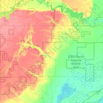
Name: Wilber Township topographic map, elevation, terrain.

Location: Wilber Township, Iosco County, Michigan, United States (44.33714 -83.64544 44.42496 -83.40070)

Average elevation: 214 m

Minimum elevation: 172 m

Maximum elevation: 264 m

Other topographic maps

Click on a map to view its topography, its elevation and its terrain.

National City

United States > Michigan > Iosco County

Average elevation: 206 m

Long Lake

United States > Michigan > Iosco County

Average elevation: 278 m

Alabaster

United States > Michigan > Iosco County

Average elevation: 181 m

Sand Lake

United States > Michigan > Iosco County

Average elevation: 241 m

Hale

United States > Michigan > Iosco County

Average elevation: 260 m

Sand Lake

United States > Michigan > Iosco County > Sand Lake

Average elevation: 240 m

Gear up for your next adventure:

🧦Merino Wool Socks - Moisture-wicking comfort for long-distance hiking
🧥Softshell Jacket - Windproof and breathable jacket for hiking
Camping Groundsheet - Protect your tent from moisture and dirt
🕶️Polarized Sunglasses - Reduces glare from snow and water at high elevations
🥾Hiking Boots - Sturdy boots providing ankle support and traction on rugged trails

As an Amazon Associate, this site earns from qualifying purchases at no extra cost to you.