
Make a donation
Gear up for your next adventure:
As an Amazon Associate, this site earns from qualifying purchases at no extra cost to you.
Gröde topographic map
Click on the map to display elevation.
Make a donation
Gear up for your next adventure:
As an Amazon Associate, this site earns from qualifying purchases at no extra cost to you.
About this map
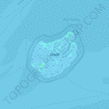
Name: Gröde topographic map, elevation, terrain.
Average elevation: 0 m
Minimum elevation: -3 m
Maximum elevation: 4 m
Make a donation
Gear up for your next adventure:
As an Amazon Associate, this site earns from qualifying purchases at no extra cost to you.
Other topographic maps
Click on a map to view its topography, its elevation and its terrain.
Make a donation
Gear up for your next adventure:
As an Amazon Associate, this site earns from qualifying purchases at no extra cost to you.
Hattstedt
Deutschland > Schleswig-Holstein > Nordfriesland > Hattstedt > Hattstedt
Die Ausdeutung der Hügelform des Geestrückens der Topographie Hattstedts lässt auf eine Hutform schließen. Der Hut im Wappenvorschlag wurde aus dem Habitus eines Mannes der Hattstedter Familie nachempfunden.
Average elevation: 6 m
Naturschutzgebiet Lütjenholmer Heidedünen
Deutschland > Schleswig-Holstein > Nordfriesland > Lütjenholm
Average elevation: 4 m
Make a donation
Gear up for your next adventure:
As an Amazon Associate, this site earns from qualifying purchases at no extra cost to you.
Make a donation
Gear up for your next adventure:
As an Amazon Associate, this site earns from qualifying purchases at no extra cost to you.
Naturschutzgebiet Süderlügumer Binnendünen
Deutschland > Schleswig-Holstein > Nordfriesland > Süderlügum
Average elevation: 9 m
Make a donation
Gear up for your next adventure:
As an Amazon Associate, this site earns from qualifying purchases at no extra cost to you.
Make a donation
Gear up for your next adventure:
As an Amazon Associate, this site earns from qualifying purchases at no extra cost to you.
Make a donation
Gear up for your next adventure:
As an Amazon Associate, this site earns from qualifying purchases at no extra cost to you.
Bongsieler Kanal
Deutschland > Schleswig-Holstein > Nordfriesland > Süder-Waygaard
Average elevation: -1 m
Make a donation
Gear up for your next adventure:
As an Amazon Associate, this site earns from qualifying purchases at no extra cost to you.
Make a donation
Gear up for your next adventure:
As an Amazon Associate, this site earns from qualifying purchases at no extra cost to you.
Stollberg
Deutschland > Schleswig-Holstein > Nordfriesland > West-Bordelum > Stollberg
Average elevation: 18 m
Make a donation
Gear up for your next adventure:
As an Amazon Associate, this site earns from qualifying purchases at no extra cost to you.
West-Bordelum
Deutschland > Schleswig-Holstein > Nordfriesland > West-Bordelum
Average elevation: 12 m
Voltswarft
Deutschland > Schleswig-Holstein > Nordfriesland > Fahretoft > Voltswarft
Average elevation: -1 m
Make a donation
Gear up for your next adventure:
As an Amazon Associate, this site earns from qualifying purchases at no extra cost to you.
Althorsbüll
Deutschland > Schleswig-Holstein > Nordfriesland > Emmelsbüll-Horsbüll
Average elevation: 0 m