
Make a donation
Gear up for your next adventure:
As an Amazon Associate, this site earns from qualifying purchases at no extra cost to you.
Peñaflor topographic map
Click on the map to display elevation.
Make a donation
Gear up for your next adventure:
As an Amazon Associate, this site earns from qualifying purchases at no extra cost to you.
Peñaflor
Como barrio rural zaragozano, está regido por una Junta Vecinal. Está a una altitud de 244 m s. n. m. y dista 15 km del centro de la ciudad. Está incluido en la Zona Rural Norte del municipio.
Make a donation
Gear up for your next adventure:
As an Amazon Associate, this site earns from qualifying purchases at no extra cost to you.
About this map
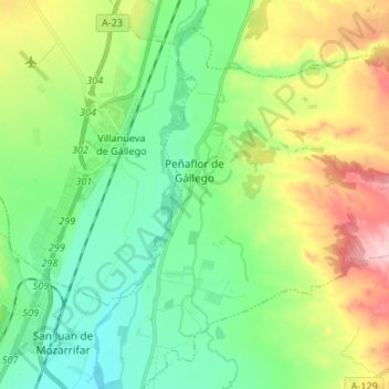
Name: Peñaflor topographic map, elevation, terrain.
Location: Peñaflor, Distrito Rural, Zaragoza, Aragón, España (41.71222 -0.82331 41.79790 -0.68954)
Average elevation: 269 m
Minimum elevation: 206 m
Maximum elevation: 398 m
Make a donation
Gear up for your next adventure:
As an Amazon Associate, this site earns from qualifying purchases at no extra cost to you.
Other topographic maps
Click on a map to view its topography, its elevation and its terrain.
Make a donation
Gear up for your next adventure:
As an Amazon Associate, this site earns from qualifying purchases at no extra cost to you.