
Thank you for supporting this site ❤️
Make a donation
Make a donation
Gear up for your next adventure:
As an Amazon Associate, this site earns from qualifying purchases at no extra cost to you.
Milford topographic map
Click on the map to display elevation.
Thank you for supporting this site ❤️
Make a donation
Make a donation
Gear up for your next adventure:
As an Amazon Associate, this site earns from qualifying purchases at no extra cost to you.
About this map
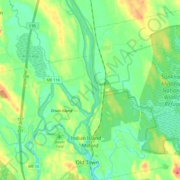
Name: Milford topographic map, elevation, terrain.
Location: Milford, Penobscot County, Maine, 04461, United States (44.92395 -68.64916 45.03936 -68.49184)
Average elevation: 40 m
Minimum elevation: 22 m
Maximum elevation: 79 m
Thank you for supporting this site ❤️
Make a donation
Make a donation
Gear up for your next adventure:
As an Amazon Associate, this site earns from qualifying purchases at no extra cost to you.
Other topographic maps
Click on a map to view its topography, its elevation and its terrain.
Spring Island
United States > Maine > Penobscot County > T4 Indian Purchase Township
Average elevation: 151 m