
Make a donation
Gear up for your next adventure:
As an Amazon Associate, this site earns from qualifying purchases at no extra cost to you.
Meulles topographic map
Click on the map to display elevation.
Make a donation
Gear up for your next adventure:
As an Amazon Associate, this site earns from qualifying purchases at no extra cost to you.
About this map
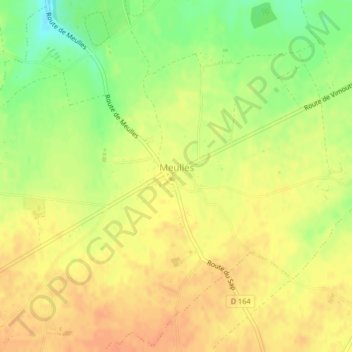
Name: Meulles topographic map, elevation, terrain.
Average elevation: 213 m
Minimum elevation: 188 m
Maximum elevation: 226 m
Make a donation
Gear up for your next adventure:
As an Amazon Associate, this site earns from qualifying purchases at no extra cost to you.
Other topographic maps
Click on a map to view its topography, its elevation and its terrain.
Make a donation
Gear up for your next adventure:
As an Amazon Associate, this site earns from qualifying purchases at no extra cost to you.
Quartier de l'Église
France > Normandie > Calvados > Livarot-Pays-d'Auge > Le Mesnil-Bacley
Average elevation: 124 m
Make a donation
Gear up for your next adventure:
As an Amazon Associate, this site earns from qualifying purchases at no extra cost to you.
Le Mesnil-Germain
France > Normandie > Calvados > Livarot-Pays-d'Auge
Le territoire de la commune est vallonné. Sa superficie est de 8,67 km2. L'altitude minimum est de 62 m à sa pointe ouest, au confluent des deux ruisseaux qui parcourent la commune (vers la RD 47 B) ; son maximum de 180 m se situe à la limite sud-est avec Cheffreville-Tonnencourt, au lieu-dit « Cour Lauzé…
Average elevation: 154 m
Cour des Sourciers
France > Normandie > Calvados > Livarot-Pays-d'Auge > Fervaques
Average elevation: 143 m
Make a donation
Gear up for your next adventure:
As an Amazon Associate, this site earns from qualifying purchases at no extra cost to you.
Manoir de Lortier
France > Normandie > Calvados > Livarot-Pays-d'Auge > Manoir de Lortier
Average elevation: 133 m
La Vatterie
France > Normandie > Calvados > Livarot-Pays-d'Auge > Préaux-Saint-Sébastien
Average elevation: 196 m