
Étables topographic map
Interactive map
Click on the map to display elevation.
About this map
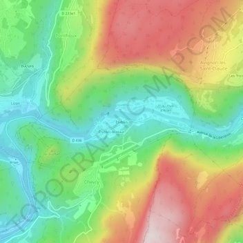
Name: Étables topographic map, elevation, terrain.
Average elevation: 627 m
Minimum elevation: 353 m
Maximum elevation: 1,007 m
Other topographic maps
Click on a map to view its topography, its elevation and its terrain.
Étables-le-Haut
France > Bourgogne-Franche-Comté > Jura > Saint-Claude > Chevry
Étables-le-Haut, Chevry, Saint-Claude, Jura, Bourgogne-Franche-Comté, France métropolitaine, 39200, France
Average elevation: 619 m
Chevry
France > Bourgogne-Franche-Comté > Jura > Saint-Claude > Chevry
Chevry, Saint-Claude, Jura, Bourgogne-Franche-Comté, France métropolitaine, 39200, France
Average elevation: 611 m