Geolocate

Molo topographic map

Click on the map to display elevation.

About this map

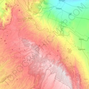
Name: Molo topographic map, elevation, terrain.

Location: Molo, Nakuru West, Nakuru, Rift Valley, 20102, Kenya (-0.53773 35.68369 -0.17184 35.91558)

Average elevation: 2,512 m

Minimum elevation: 1,862 m

Maximum elevation: 3,067 m

Other topographic maps

Click on a map to view its topography, its elevation and its terrain.

Kenya

Kenya > Nakuru > Nakuru East > Nakuru East ward

Average elevation: 1,831 m

Wild Fire

Kenya > Nakuru > Naivasha > Hells Gate ward > Junction 1

Average elevation: 1,952 m

Fire

Kenya > Nakuru

Average elevation: 1,832 m

Mai Maihu

Kenya > Nakuru

Average elevation: 1,868 m

Gear up for your next adventure:

🧣Merino Neck Gaiter - Protects against wind, sun, and cold at high altitudes
🧴Insect Repellent - Protect yourself from bugs during outdoor adventures
🥾Trail Running Boots - Durable shoes designed for trail running
🥾Hiking Shorts - Breathable shorts suitable for summer hikes
💡Compact LED Flashlight - Powerful and portable flashlight for outdoor use

As an Amazon Associate, this site earns from qualifying purchases at no extra cost to you.