Geolocate

Ol Kalou topographic map

Click on the map to display elevation.

About this map

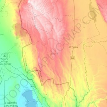
Name: Ol Kalou topographic map, elevation, terrain.

Location: Ol Kalou, Nyandarua, Central Kenya, Kenya (-0.46090 36.20154 -0.11721 36.46352)

Average elevation: 2,298 m

Minimum elevation: 1,774 m

Maximum elevation: 2,867 m

Other topographic maps

Click on a map to view its topography, its elevation and its terrain.

Mount Satima

Kenya > Nyandarua

Average elevation: 3,805 m

Gear up for your next adventure:

🥾Trekking Poles - Adjustable trekking poles to reduce knee stress and improve stability
🧥Thermal Fleece Jacket - Versatile insulation for changing mountain temperatures
🥾Approach Boots - Comfortable boots for hiking and climbing approaches
📷Outdoor Action Camera - Capture high-elevation views and rugged adventures
🧴Sunscreen SPF - Broad-spectrum sunscreen for outdoor activities

As an Amazon Associate, this site earns from qualifying purchases at no extra cost to you.