Geolocate

Okehampton topographic map

Click on the map to display elevation.

About this map

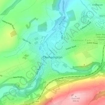
Name: Okehampton topographic map, elevation, terrain.

Location: Okehampton, West Devon, Devon, England, United Kingdom (50.72846 -4.01589 50.74924 -3.98402)

Average elevation: 206 m

Minimum elevation: 135 m

Maximum elevation: 346 m

Gear up for your next adventure:

🧰Multitool Knife - Compact and versatile tool for outdoor use
🥾Light Hiking Boots - Lightweight and comfortable boots for day hikes
🧭Orienteering Kit - Tools for map reading and navigation in the wild
🧥Packable Rain Jacket - Breathable waterproof layer for unpredictable weather
🧥Softshell Hiking Jacket - The perfect balance of wind protection and breathability

As an Amazon Associate, this site earns from qualifying purchases at no extra cost to you.