Geolocate

Deha topographic map

Click on the map to display elevation.

About this map

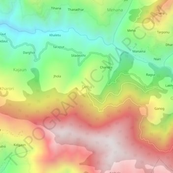
Name: Deha topographic map, elevation, terrain.

Location: Deha, Theog, Shimla, Himachal Pradesh, India (31.02382 77.43489 31.06382 77.47489)

Average elevation: 2,048 m

Minimum elevation: 1,451 m

Maximum elevation: 2,686 m

Gear up for your next adventure:

🧦Outdoor Socks - Durable socks designed for hiking and outdoor sports
🥾Mountain Trail Shoes - High-traction shoes for mountain trails
🎒Backpack Rain Cover - External shield to keep your entire pack dry
🪑Insulated Seat Pad - Protect your seat from cold rocks and wet logs
🩹Moleskin Blister Pads - Direct protection for painful foot pressure points

As an Amazon Associate, this site earns from qualifying purchases at no extra cost to you.