
caïdat d'Angad topographic map
Interactive map
Click on the map to display elevation.
About this map
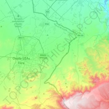
Name: caïdat d'Angad topographic map, elevation, terrain.
Average elevation: 664 m
Minimum elevation: 293 m
Maximum elevation: 1,582 m
Other topographic maps
Click on a map to view its topography, its elevation and its terrain.
Ouled Zerrouk
Maroc > cercle d'Oujda-Banlieue nord > Bni Khaled
Ouled Zerrouk, Bni Khaled, caïdat de Bni Khaled, cercle d'Oujda-Banlieue nord, Préfecture d'Oujda-Angad, Oriental, Maroc
Average elevation: 461 m
Aïn Almou
Maroc > cercle d'Oujda-Banlieue nord > Ain Sfa
Aïn Almou, Ain Sfa, caïdat d'Aïn Sfa, cercle d'Oujda-Banlieue nord, Préfecture d'Oujda-Angad, Oriental, Maroc
Average elevation: 1,285 m
Ain Sfa
Maroc > cercle d'Oujda-Banlieue nord > Ain Sfa
Ain Sfa, caïdat d'Aïn Sfa, cercle d'Oujda-Banlieue nord, Préfecture d'Oujda-Angad, Oriental, 60005, Maroc
Average elevation: 703 m