Geolocate

Solaris topographic map

Click on the map to display elevation.

About this map

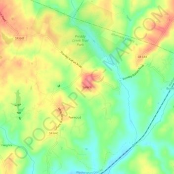
Name: Solaris topographic map, elevation, terrain.

Location: Solaris, Albemarle County, Virginia, 22923, United States (38.14819 -78.38473 38.18819 -78.34473)

Average elevation: 145 m

Minimum elevation: 111 m

Maximum elevation: 181 m

Other topographic maps

Click on a map to view its topography, its elevation and its terrain.

Crozet

United States > Virginia > Albemarle County > Crozet

Average elevation: 208 m

Keswick

United States > Virginia > Albemarle County > Keswick

Average elevation: 127 m

Rio

United States > Virginia > Albemarle County > Rio

Average elevation: 149 m

Ivy

United States > Virginia > Albemarle County

Average elevation: 187 m

Rio

United States > Virginia > Albemarle County > Rio

Average elevation: 149 m

Lake

United States > Virginia > Albemarle County > Hollymead

Average elevation: 151 m

Crozet

United States > Virginia > Albemarle County > Crozet

Average elevation: 208 m

Gear up for your next adventure:

🐕Hiking Dog Pack - Let your canine companion carry their own water and food
🏃Hydration Running Vest - Carry water and maps close to your body for speed
🧢Hiking Hat - Sun-protective and breathable hats for long treks
🧢Sun Protection Cap - Breathable cap to protect from sun exposure
🚲Handlebar Phone Mount - View topographic-map.com live while cycling

As an Amazon Associate, this site earns from qualifying purchases at no extra cost to you.