Geolocate

Ibiraci topographic map

Click on the map to display elevation.

Ibiraci

The city center of Ibiraci is located at an elevation of 1,071 meters northwest of the regional center of Passos and northeast of Franca. Neighboring municipalities are: Sacramento and Delfinópolis (N), Cássia (E), Capetinga, Itirapuã, and Patrocínio Paulista (S), Franca and Claraval (W).

Wikipedia (CC-BY-SA 3.0)

About this map

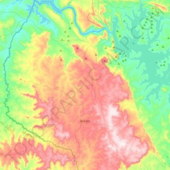
Name: Ibiraci topographic map, elevation, terrain.

Location: Ibiraci, Região Geográfica Imediata de Passos, Região Geográfica Intermediária de Varginha, Minas Gerais, Southeast Region, Brazil (-20.56090 -47.23278 -20.21895 -46.97500)

Average elevation: 888 m

Minimum elevation: 616 m

Maximum elevation: 1,285 m

Other topographic maps

Click on a map to view its topography, its elevation and its terrain.

Bento Rodrigues

Brazil > Minas Gerais > Mariana

Average elevation: 780 m

Lecythis pisonis

Brazil > Minas Gerais > Sete Lagoas

Average elevation: 776 m

Lourenço Velho

Brazil > Minas Gerais > Itajubá > Lourenço Velho

Average elevation: 1,126 m

Belo Horizonte

Brazil > Minas Gerais > Região Metropolitana de Belo Horizonte > Belo Horizonte

In 1893, due to the climatic and topographic conditions, Curral Del Rey was selected by Minas Gerais governor Afonso Pena among other cities as the location for the new economic and cultural center of the state, under the new name of Cidade de Minas, or City of Minas.

Average elevation: 904 m

Hargreaves

Brazil > Minas Gerais > Ouro Preto

Average elevation: 1,187 m

Gear up for your next adventure:

🥾Trail Hiking Socks - Comfortable socks to prevent blisters and fatigue
🔥Camping Stove - Portable stoves to cook outdoors with ease
🕶️Polarized Sunglasses - Reduces glare from snow and water at high elevations
🏃Hydration Running Vest - Carry water and maps close to your body for speed
🧦Hiking Socks - Moisture-wicking and comfortable socks for long hikes

As an Amazon Associate, this site earns from qualifying purchases at no extra cost to you.