Geolocate

Tennyson topographic map

Click on the map to display elevation.

About this map

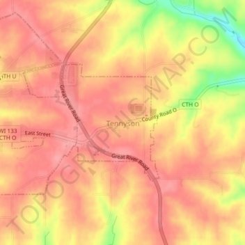
Name: Tennyson topographic map, elevation, terrain.

Location: Tennyson, Grant County, Wisconsin, United States (42.68356 -90.69432 42.69649 -90.67969)

Average elevation: 282 m

Minimum elevation: 217 m

Maximum elevation: 306 m

Other topographic maps

Click on a map to view its topography, its elevation and its terrain.

Mississippi River

United States > Wisconsin > Grant County > Dubuque

The uppermost lock and dam on the Upper Mississippi River is the Upper St. Anthony Falls Lock and Dam in Minneapolis. Above the dam, the river's elevation is 799 feet (244 m). Below the dam, the river's elevation is 750 feet (230 m). This 49-foot (15 m) drop is the largest of all the Mississippi River locks…

Average elevation: 203 m

Van Buren

United States > Wisconsin > Grant County > Potosi

Average elevation: 242 m

Stitzer

United States > Wisconsin > Grant County

Average elevation: 331 m

Sinsinawa

United States > Wisconsin > Grant County

Average elevation: 277 m

Sandy Hook

United States > Wisconsin > Grant County

Average elevation: 245 m

Kieler

United States > Wisconsin > Grant County

Average elevation: 275 m

Gear up for your next adventure:

🧼Travel Hand Sanitizer - Keep hands clean when water is scarce
🧭GPS Outdoor Watch - Smart watch for navigation and fitness tracking in nature
👟Leg Gaiters - Keep debris, mud, and snow out of your boots
Camping Groundsheet - Protect your tent from moisture and dirt
🥾Waterproof Hiking Boots - Essential footwear for rugged terrain and wet Canadian trails

As an Amazon Associate, this site earns from qualifying purchases at no extra cost to you.