
Make a donation
Gear up for your next adventure:
As an Amazon Associate, this site earns from qualifying purchases at no extra cost to you.
Rimplas topographic map
Click on the map to display elevation.
Make a donation
Gear up for your next adventure:
As an Amazon Associate, this site earns from qualifying purchases at no extra cost to you.
About this map
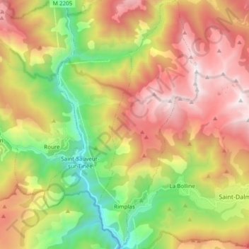
Name: Rimplas topographic map, elevation, terrain.
Average elevation: 1,480 m
Minimum elevation: 414 m
Maximum elevation: 2,663 m
Make a donation
Gear up for your next adventure:
As an Amazon Associate, this site earns from qualifying purchases at no extra cost to you.
Other topographic maps
Click on a map to view its topography, its elevation and its terrain.
Auron
Frankrijk > Provence-Alpes-Côte d'Azur > Alpes-Maritimes > Saint-Étienne-de-Tinée
Average elevation: 1,654 m
Carel
Frankrijk > Provence-Alpes-Côte d'Azur > Alpes-Maritimes > Auribeau-sur-Siagne
Average elevation: 113 m
Le Haut Cheiron
Frankrijk > Provence-Alpes-Côte d'Azur > Alpes-Maritimes > Coursegoules
Average elevation: 1,376 m
Make a donation
Gear up for your next adventure:
As an Amazon Associate, this site earns from qualifying purchases at no extra cost to you.