Geolocate

Simonshofen topographic map

Click on the map to display elevation.

Simonshofen

Das Dorf befindet sich etwa vier Kilometer nördlich des Ortszentrum von Lauf und liegt auf einer Höhe von 374 m ü. NHN.

Wikipedia (CC-BY-SA 3.0)

About this map

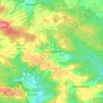
Name: Simonshofen topographic map, elevation, terrain.

Location: Simonshofen, Lauf an der Pegnitz, Landkreis Nürnberger Land, Bayern, 91207, Deutschland (49.53179 11.24801 49.57179 11.28801)

Average elevation: 378 m

Minimum elevation: 340 m

Maximum elevation: 426 m

Gear up for your next adventure:

🔥Emergency Fire Starter - Reliable ignition source for all weather conditions
🛌Insulated Sleeping Pad - Critical thermal barrier between you and the cold ground
🧥Waterproof Pants - Keep dry during rainy hiking conditions
🧰Emergency Multi-Tool - Compact multi-tool for outdoor survival
🥾Hiking Boots - Sturdy boots providing ankle support and traction on rugged trails

As an Amazon Associate, this site earns from qualifying purchases at no extra cost to you.