
Make a donation
Gear up for your next adventure:
As an Amazon Associate, this site earns from qualifying purchases at no extra cost to you.
Wilmot topographic map
Click on the map to display elevation.
Make a donation
Gear up for your next adventure:
As an Amazon Associate, this site earns from qualifying purchases at no extra cost to you.
Wilmot
Mount Kearsarge, elevation 2,931 feet (893 m) above sea level, on the southern border, is the highest point in town and in Merrimack County. Winslow State Park, at the northern foot of the mountain, provides access by two hiking trails to the summit. The state park and the Winslow Trail are named after Captain John Winslow, the commander of the USS Kearsarge, which in June 1864 sank the CSS Alabama in the English Channel in a famous Civil War sea battle.
Make a donation
Gear up for your next adventure:
As an Amazon Associate, this site earns from qualifying purchases at no extra cost to you.
About this map
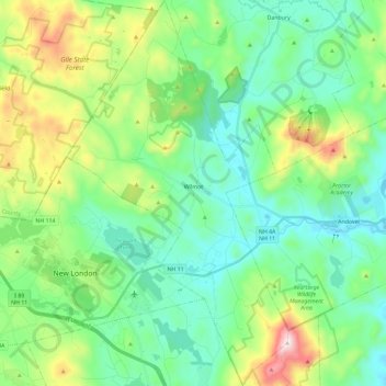
Name: Wilmot topographic map, elevation, terrain.
Location: Wilmot, Merrimack County, New Hampshire, United States (43.36446 -71.99031 43.53353 -71.85623)
Average elevation: 364 m
Minimum elevation: 180 m
Maximum elevation: 885 m
Make a donation
Gear up for your next adventure:
As an Amazon Associate, this site earns from qualifying purchases at no extra cost to you.