Geolocate

Puze topographic map

Click on the map to display elevation.

About this map

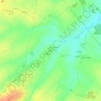
Name: Puze topographic map, elevation, terrain.

Location: Puze, Champigny-le-Sec, Champigny en Rochereau, Poitiers, Vienne, Nouvelle-Aquitaine, France métropolitaine, 86170, France (46.70492 0.15050 46.74492 0.19050)

Average elevation: 108 m

Minimum elevation: 89 m

Maximum elevation: 132 m

Other topographic maps

Click on a map to view its topography, its elevation and its terrain.

Gear up for your next adventure:

🥾Trail Hiking Boots - Supportive boots for rough trails
🥾Hiking Shorts - Breathable shorts suitable for summer hikes
🧢Sun Hat - Wide-brim hat for sun protection
🧼Travel Hand Sanitizer - Keep hands clean when water is scarce
🚲Handlebar Phone Mount - View topographic-map.com live while cycling

As an Amazon Associate, this site earns from qualifying purchases at no extra cost to you.