Geolocate

Riberalta topographic map

Click on the map to display elevation.

About this map

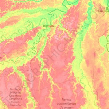
Name: Riberalta topographic map, elevation, terrain.

Location: Riberalta, Antonio Vaca Díez, Beni, Bolivia (-12.00378 -66.49159 -10.68831 -65.46511)

Average elevation: 148 m

Minimum elevation: 108 m

Maximum elevation: 182 m

Other topographic maps

Click on a map to view its topography, its elevation and its terrain.

Buenos Aires

Bolivia > Beni > Antonio Vaca Díez > Guayaramerín

Average elevation: 137 m

Gear up for your next adventure:

🧴Outdoor Sunscreen - High SPF protection for high-altitude UV exposure
🥽Outdoor Goggles - Protective eyewear for outdoor activities
💧Hydration Bladder - Hands-free hydration solution for long treks
🩹Compact First Aid Kit - Pre-packed essentials for common trail injuries
🧣Merino Neck Gaiter - Protects against wind, sun, and cold at high altitudes

As an Amazon Associate, this site earns from qualifying purchases at no extra cost to you.