
Make a donation
Gear up for your next adventure:
As an Amazon Associate, this site earns from qualifying purchases at no extra cost to you.
Carijana topographic map
Click on the map to display elevation.
Make a donation
Gear up for your next adventure:
As an Amazon Associate, this site earns from qualifying purchases at no extra cost to you.
About this map
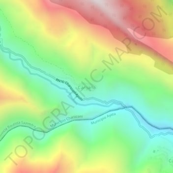
Name: Carijana topographic map, elevation, terrain.
Average elevation: 1,993 m
Minimum elevation: 1,412 m
Maximum elevation: 2,813 m
Make a donation
Gear up for your next adventure:
As an Amazon Associate, this site earns from qualifying purchases at no extra cost to you.
Other topographic maps
Click on a map to view its topography, its elevation and its terrain.
Soto Pata
Bolivia > La Paz > Provincia Bautista Saavedra > Municipio Charazani
Average elevation: 1,020 m
Pauje Yuyo
Bolivia > La Paz > Provincia Bautista Saavedra > Municipio Charazani
Average elevation: 1,215 m
Santa Rosa de Caata
Bolivia > La Paz > Provincia Bautista Saavedra > Municipio Charazani
Average elevation: 3,653 m