Geolocate

River Rouge topographic map

Click on the map to display elevation.

About this map

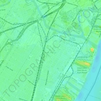
Name: River Rouge topographic map, elevation, terrain.

Location: River Rouge, Wayne County, Michigan, 48218, United States (42.25719 -83.15312 42.29023 -83.09838)

Average elevation: 178 m

Minimum elevation: 169 m

Maximum elevation: 199 m

Other topographic maps

Click on a map to view its topography, its elevation and its terrain.

Perrinville

United States > Michigan > Wayne County > Westland

Average elevation: 195 m

Sunnyside

United States > Michigan > Wayne County > Romulus

Average elevation: 194 m

Calvert Park

United States > Michigan > Wayne County > Detroit

Average elevation: 196 m

Elm

United States > Michigan > Wayne County > Livonia

Average elevation: 195 m

Newburg

United States > Michigan > Wayne County > Livonia

Average elevation: 209 m

Dearborn

United States > Michigan > Wayne County > Dearborn

Average elevation: 190 m

Gear up for your next adventure:

🥾Trail Running Boots - Durable shoes designed for trail running
🕯️Camping Lantern - Illuminates your entire campsite with high-efficiency LEDs
🩹Compact First Aid Kit - Pre-packed essentials for common trail injuries
🛶Waterproof Dry Bags - Keep electronics and clothes dry during river crossings
Camping Coffee Maker - Brew fresh coffee anywhere on the topographic map

As an Amazon Associate, this site earns from qualifying purchases at no extra cost to you.