
Thank you for supporting this site ❤️
Make a donation
Make a donation
Gear up for your next adventure:
As an Amazon Associate, this site earns from qualifying purchases at no extra cost to you.
Kudhës topographic map
Click on the map to display elevation.
Thank you for supporting this site ❤️
Make a donation
Make a donation
Gear up for your next adventure:
As an Amazon Associate, this site earns from qualifying purchases at no extra cost to you.
About this map
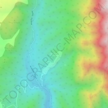
Name: Kudhës topographic map, elevation, terrain.
Location: Kudhës, Himarë, Bashkia Himarë, Vlorë County, 9425, Albania (40.08287 19.79756 40.12287 19.83756)
Average elevation: 462 m
Minimum elevation: 46 m
Maximum elevation: 1,331 m
Thank you for supporting this site ❤️
Make a donation
Make a donation
Gear up for your next adventure:
As an Amazon Associate, this site earns from qualifying purchases at no extra cost to you.