Geolocate

Lawy topographic map

Click on the map to display elevation.

About this map

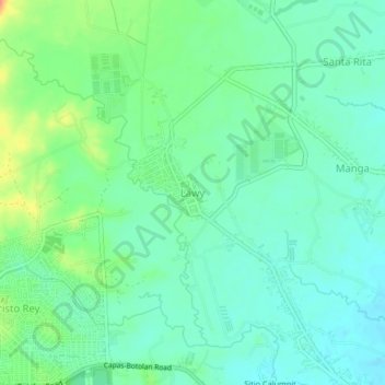
Name: Lawy topographic map, elevation, terrain.

Location: Lawy, Capas, Tarlac, Central Luzon, Philippines (15.35292 120.53615 15.39292 120.57615)

Average elevation: 67 m

Minimum elevation: 53 m

Maximum elevation: 97 m

Other topographic maps

Click on a map to view its topography, its elevation and its terrain.

Tambo Lake

Philippines > Tarlac > Capas

Average elevation: 292 m

O' Donnel River

Philippines > Tarlac > Capas

Average elevation: 222 m

Gear up for your next adventure:

🧤Rechargeable Heated Gloves - Extreme warmth for Canadian winter expeditions
👖Convertible Hiking Pants - Zip-off legs to adapt to changing weather conditions
🦌Outdoor Trail Camera - Monitor wildlife activity near your favorite spots
Camping Tent - Weather-resistant tents suitable for 2 to 6 people
🧶550 Survival Paracord - Versatile utility cord for emergency repairs and rigging

As an Amazon Associate, this site earns from qualifying purchases at no extra cost to you.