Geolocate

Tanyfron topographic map

Click on the map to display elevation.

About this map

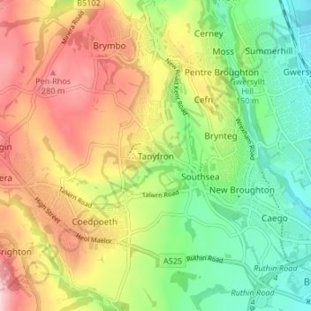
Name: Tanyfron topographic map, elevation, terrain.

Location: Tanyfron, Wrexham, Wales, LL11 5SB, United Kingdom (53.04240 -3.07086 53.08240 -3.03086)

Average elevation: 178 m

Minimum elevation: 81 m

Maximum elevation: 298 m

Other topographic maps

Click on a map to view its topography, its elevation and its terrain.

Gwersyllt

United Kingdom > Wales > Wrexham

Average elevation: 112 m

Penycae

United Kingdom > Wales > Wrexham

Average elevation: 350 m

Rhosddu

United Kingdom > Wales > Wrexham

Average elevation: 88 m

Bangor-on-Dee

United Kingdom > Wales > Wrexham

Average elevation: 30 m

Cefn

United Kingdom > Wales > Wrexham > Acrefair

Average elevation: 142 m

Gear up for your next adventure:

🧦Thermal Socks - Warm socks for winter hiking or camping
🎒Hiking Backpack - Lightweight and ergonomic backpacks for day hikes or multi-day treks
🔭Compact Monocular - One-handed bird watching and trail spotting
🧣Evaporative Cooling Towel - Beat the heat during intense summer climbs
🧥Waterproof Jacket - Lightweight rain jackets for hiking and outdoor activities

As an Amazon Associate, this site earns from qualifying purchases at no extra cost to you.