Geolocate

Merésichic topographic map

Click on the map to display elevation.

About this map

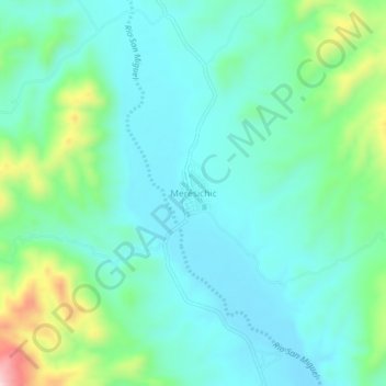
Name: Merésichic topographic map, elevation, terrain.

Location: Merésichic, Opodepe, Sonora, Mexico (30.01044 -110.69524 30.05044 -110.65524)

Average elevation: 763 m

Minimum elevation: 688 m

Maximum elevation: 1,018 m

Gear up for your next adventure:

🐕Hiking Dog Pack - Let your canine companion carry their own water and food
🥾Durable Hiking Shoes - Long-lasting shoes for frequent hiking
🥾Trekking Poles - Adjustable trekking poles to reduce knee stress and improve stability
💡Compact LED Flashlight - Powerful and portable flashlight for outdoor use
🔦UV Flashlight - Detect minerals or specific insects in the dark

As an Amazon Associate, this site earns from qualifying purchases at no extra cost to you.