Geolocate

Maasin topographic map

Click on the map to display elevation.

About this map

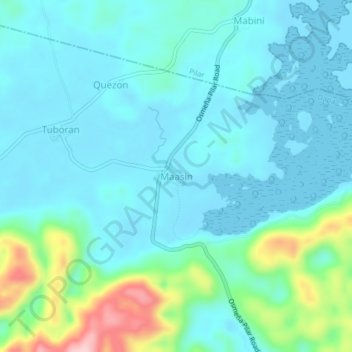
Name: Maasin topographic map, elevation, terrain.

Location: Maasin, Quezon, Pilar, Surigao del Norte, Caraga, Philippines (9.79993 126.03714 9.83993 126.07714)

Average elevation: 40 m

Minimum elevation: 0 m

Maximum elevation: 215 m

Gear up for your next adventure:

🦟Insect Repellent - Keep mosquitoes and black flies away in wooded areas
👖Convertible Hiking Pants - Zip-off legs to adapt to changing weather conditions
🥾Trekking Boots - Durable boots for long-distance trekking
🥾Light Trekking Boots - Supportive boots for multi-day treks
🔋Emergency Crank Radio - Weather alerts and power without needing batteries

As an Amazon Associate, this site earns from qualifying purchases at no extra cost to you.