Geolocate

Yapatera topographic map

Click on the map to display elevation.

About this map

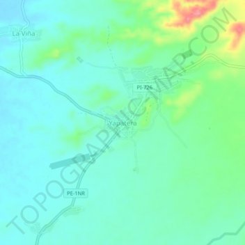
Name: Yapatera topographic map, elevation, terrain.

Location: Yapatera, Chulucanas, Morropón, Piura, Perú (-5.08159 -80.15922 -5.04159 -80.11922)

Average elevation: 111 m

Minimum elevation: 89 m

Maximum elevation: 185 m

Other topographic maps

Click on a map to view its topography, its elevation and its terrain.

Plaza de Armas

Perú > Piura > Chulucanas

Average elevation: 94 m

Gear up for your next adventure:

🛶Kayak Dry Bag - Waterproof storage for kayaking adventures
🧦Hiking Liner Socks - Thin base layer to prevent friction and blisters
🧴Insect Repellent - Protect yourself from bugs during outdoor adventures
🔦LED Flashlight - Powerful and long-lasting flashlight for camping and emergencies
🔦LED Headtorch - Bright and durable light for night activities

As an Amazon Associate, this site earns from qualifying purchases at no extra cost to you.