Geolocate

Guanyang topographic map

Click on the map to display elevation.

About this map

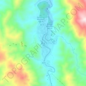
Name: Guanyang topographic map, elevation, terrain.

Location: Guanyang, Nanjing County, Zhangzhou City, Fujian, China (24.64473 117.06869 24.68473 117.10869)

Average elevation: 589 m

Minimum elevation: 429 m

Maximum elevation: 942 m

Gear up for your next adventure:

🦟Insect Repellent - Keep mosquitoes and black flies away in wooded areas
🧰Multitool Knife - Compact and versatile tool for outdoor use
🩹Moleskin Blister Pads - Direct protection for painful foot pressure points
🛁Quick-Dry Microfiber Towel - Space-saving towel that dries rapidly on the move
🧭GPS Tracker - Track your location in remote areas safely

As an Amazon Associate, this site earns from qualifying purchases at no extra cost to you.