

Mürren topographic map
Click on the map to display elevation.
About this map
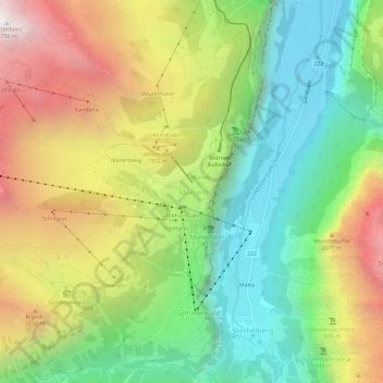
Name: Mürren topographic map, elevation, terrain.
Average elevation: 1,597 m
Minimum elevation: 799 m
Maximum elevation: 2,735 m
Other topographic maps
Click on a map to view its topography, its elevation and its terrain.
Grindelwald
Switzerland > Bern > Interlaken-Oberhasli administrative district
Average elevation: 2,218 m
Lauterbrunnen
Switzerland > Bern > Interlaken-Oberhasli administrative district
Average elevation: 2,315 m
Innertkirchen
Switzerland > Bern > Interlaken-Oberhasli administrative district
The large alpine municipality is located at the confluence of the Urbach and Gadmer streams into the Aare river. It includes the Urbach valley, the Gadmen valley, the Gen valley, the Wetterhorn mountain and the Gauli Glacier. Innertkirchen was created out of the Bäuerten (farming communities) of Grund,…
Average elevation: 1,963 m
Lauterbrunnen
Switzerland > Bern > Interlaken-Oberhasli administrative district
Average elevation: 2,315 m
Grindelwald
Switzerland > Bern > Interlaken-Oberhasli administrative district
Average elevation: 2,219 m
Hasliberg
Switzerland > Bern > Interlaken-Oberhasli administrative district
The main inhabited area of Hasliberg is situated on a south-west facing terrace above the valley of the river Aare, at an approximate altitude of 1,000 m (3,300 ft). Spread out along this terrace are the villages of Hohfluh, Wasserwendi, Goldern and Reuti. To the north and east the municipality spreads out…
Average elevation: 1,414 m
Grindelwald
Switzerland > Bern > Interlaken-Oberhasli administrative district
Average elevation: 2,218 m

Meiringen
Switzerland > Bern > Interlaken-Oberhasli administrative district
On the right bank of the Aare, the municipality of Meiringen rises from an elevation of 600 m (2,000 ft) on the valley floor to the Brünig Pass at 1,008 m (3,307 ft) and beyond that to a point at 1,375 m (4,511 ft) on the slopes of the Wilerhorn. On the left bank it stretches up into the Alps and reaches an…
Average elevation: 1,430 m
Innertkirchen
Switzerland > Bern > Interlaken-Oberhasli administrative district > Innertkirchen
The large alpine municipality is located at the confluence of the Urbach and Gadmer streams into the Aare river. It includes the Urbach valley, the Gadmen valley, the Gen valley, the Wetterhorn mountain and the Gauli Glacier. Innertkirchen was created out of the Bäuerten (farming communities) of Grund,…
Average elevation: 1,945 m
Beatenberg
Switzerland > Bern > Interlaken-Oberhasli administrative district
Average elevation: 1,281 m
Grindelwald
Switzerland > Bern > Interlaken-Oberhasli administrative district
Average elevation: 2,218 m
Iseltwald
Switzerland > Bern > Interlaken-Oberhasli administrative district
The municipality's area also includes a large area of mountainside along the south shore of the lake, of which the lower areas are heavily wooded. These slopes extend up to the summit of the Faulhorn mountain, at an altitude of 2,680 m (8,790 ft).
Average elevation: 1,218 m
Lauterbrunnen
Switzerland > Bern > Interlaken-Oberhasli administrative district
Average elevation: 2,316 m
Brienz (BE)
Switzerland > Bern > Interlaken-Oberhasli administrative district
Average elevation: 1,426 m
Lauterbrunnen
Switzerland > Bern > Interlaken-Oberhasli administrative district
Average elevation: 2,315 m

Wilderswil
Switzerland > Bern > Interlaken-Oberhasli administrative district
The municipality extends for some 8 km (5.0 mi) from the village, along the west bank of the Lütschine river, and includes the flanks of the mountains that border that valley to the west. Its altitude ranges from some 580 m (1,900 ft), on the Bödeli plain, to 2,413 m (7,917 ft), at the summit of Sulegg. It…
Average elevation: 1,198 m
Grindelwald
Switzerland > Bern > Interlaken-Oberhasli administrative district
Average elevation: 2,218 m
Gündlischwand
Switzerland > Bern > Interlaken-Oberhasli administrative district
Average elevation: 1,268 m
Meiringen
Switzerland > Bern > Interlaken-Oberhasli administrative district
On the right bank of the Aare, the municipality of Meiringen rises from an elevation of 600 m (2,000 ft) on the valley floor to the Brünig Pass at 1,008 m (3,307 ft) and beyond that to a point at 1,375 m (4,511 ft) on the slopes of the Wilerhorn. On the left bank it stretches up into the Alps and reaches an…
Average elevation: 1,430 m
Innertkirchen
Switzerland > Bern > Interlaken-Oberhasli administrative district
The large alpine municipality is located at the confluence of the Urbach and Gadmer streams into the Aare river. It includes the Urbach valley, the Gadmen valley, the Gen valley, the Wetterhorn mountain and the Gauli Glacier. Innertkirchen was created out of the Bäuerten (farming communities) of Grund,…
Average elevation: 1,963 m
Grindelwald
Switzerland > Bern > Interlaken-Oberhasli administrative district
Average elevation: 2,218 m
Brienz (BE)
Switzerland > Bern > Interlaken-Oberhasli administrative district
Average elevation: 1,426 m
Matten bei Interlaken
Switzerland > Bern > Interlaken-Oberhasli administrative district
Average elevation: 781 m
Matten bei Interlaken
Switzerland > Bern > Interlaken-Oberhasli administrative district
Average elevation: 783 m
Beatenberg
Switzerland > Bern > Interlaken-Oberhasli administrative district
Average elevation: 1,281 m
Grindelwald
Switzerland > Bern > Interlaken-Oberhasli administrative district
Average elevation: 2,218 m
Triftsee
Switzerland > Bern > Interlaken-Oberhasli administrative district > Innertkirchen
Average elevation: 2,025 m
Brienz (BE)
Switzerland > Bern > Interlaken-Oberhasli administrative district
Average elevation: 1,426 m
Lauterbrunnen
Switzerland > Bern > Interlaken-Oberhasli administrative district
Average elevation: 2,316 m
Beatenberg
Switzerland > Bern > Interlaken-Oberhasli administrative district
Average elevation: 1,281 m
Brienz (BE)
Switzerland > Bern > Interlaken-Oberhasli administrative district
Average elevation: 1,426 m
Guttannen
Switzerland > Bern > Interlaken-Oberhasli administrative district
By Swiss standards, the municipality is large in area; by comparison it is larger than the entire Canton of Appenzell Innerrhoden. In elevation it stretches from the valley floor which is between 800–1,300 m (2,600–4,300 ft) into the high alpine peaks of the Finsteraarhorn group.
Average elevation: 2,334 m
Lütschental
Switzerland > Bern > Interlaken-Oberhasli administrative district
Average elevation: 1,546 m
Gsteigwiler
Switzerland > Bern > Interlaken-Oberhasli administrative district > Gsteigwiler
Average elevation: 984 m
Unteraargletscher
Switzerland > Bern > Interlaken-Oberhasli administrative district > Guttannen
Average elevation: 2,631 m