Geolocate

Lopang topographic map

Click on the map to display elevation.

About this map

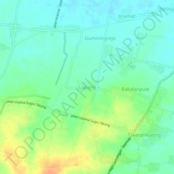
Name: Lopang topographic map, elevation, terrain.

Location: Lopang, Lamongan, East Java, Java, 62218, Indonesia (-7.19021 112.36315 -7.15021 112.40315)

Average elevation: 18 m

Minimum elevation: 5 m

Maximum elevation: 40 m

Other topographic maps

Click on a map to view its topography, its elevation and its terrain.

Sidokumpul

Indonesia > East Java > Lamongan > Sambeng

Average elevation: 74 m

Gondang Dam

Indonesia > East Java > Lamongan > Deketagung

Average elevation: 39 m

Lamongan

Indonesia > East Java > Lamongan

Average elevation: 30 m

Gear up for your next adventure:

🛶Kayak Accessories - Essential gear for safe and fun kayaking adventures
🥾Durable Hiking Shoes - Long-lasting shoes for frequent hiking
🧥Softshell Jacket - Windproof and breathable jacket for hiking
🔋Solar Power Bank - Keep your GPS and devices charged during long outdoor trips
🧤Thermal Hiking Gloves - Grip-enhanced gloves for cold-weather altitude trekking

As an Amazon Associate, this site earns from qualifying purchases at no extra cost to you.