
Capoluogo topographic map
Interactive map
Click on the map to display elevation.
About this map
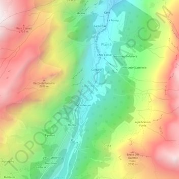
Name: Capoluogo topographic map, elevation, terrain.
Location: Capoluogo, Planté, Valgrisenche, Vallée d'Aoste, Italie (45.61024 7.04400 45.65024 7.08400)
Average elevation: 2,216 m
Minimum elevation: 1,549 m
Maximum elevation: 3,037 m
Other topographic maps
Click on a map to view its topography, its elevation and its terrain.
Cére
Italie > Vallée d'Aoste > Planté > Cére
Cére, Planté, Valgrisenche, Vallée d'Aoste, Italie
Average elevation: 2,170 m