
Make a donation
Gear up for your next adventure:
As an Amazon Associate, this site earns from qualifying purchases at no extra cost to you.
Kuchenheim topographic map
Click on the map to display elevation.
Make a donation
Gear up for your next adventure:
As an Amazon Associate, this site earns from qualifying purchases at no extra cost to you.
Kuchenheim
An der Südseite des Ortes stand seit 1467 auf einer kleinen Anhöhe (genannt Schießberg, weil man vonseiten der Sebastianus-Schützen drei Schüsse zu Ehren der Dreifaltigkeit abfeuerte, wenn an dem Prozessionskreuz der Segen erteilt worden war) ein Kreuz aus grauem Sandstein, von dem Leheninhaber der oberen Burg, Johann von Kinzweiler, errichtet.
Make a donation
Gear up for your next adventure:
As an Amazon Associate, this site earns from qualifying purchases at no extra cost to you.
About this map
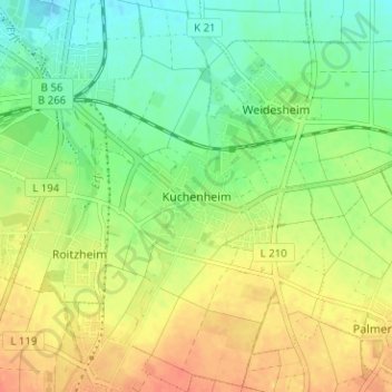
Name: Kuchenheim topographic map, elevation, terrain.
Average elevation: 175 m
Minimum elevation: 154 m
Maximum elevation: 197 m
Make a donation
Gear up for your next adventure:
As an Amazon Associate, this site earns from qualifying purchases at no extra cost to you.
Other topographic maps
Click on a map to view its topography, its elevation and its terrain.
Make a donation
Gear up for your next adventure:
As an Amazon Associate, this site earns from qualifying purchases at no extra cost to you.