
Thank you for supporting this site ❤️
Make a donation
Make a donation
Gear up for your next adventure:
As an Amazon Associate, this site earns from qualifying purchases at no extra cost to you.
Bratto topographic map
Click on the map to display elevation.
Thank you for supporting this site ❤️
Make a donation
Make a donation
Gear up for your next adventure:
As an Amazon Associate, this site earns from qualifying purchases at no extra cost to you.
About this map
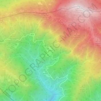
Name: Bratto topographic map, elevation, terrain.
Location: Bratto, Pontremoli, Massa-Carrara, Toscana, Italia (44.43367 9.82823 44.47367 9.86823)
Average elevation: 1,012 m
Minimum elevation: 501 m
Maximum elevation: 1,542 m
Thank you for supporting this site ❤️
Make a donation
Make a donation
Gear up for your next adventure:
As an Amazon Associate, this site earns from qualifying purchases at no extra cost to you.