
Make a donation
Gear up for your next adventure:
As an Amazon Associate, this site earns from qualifying purchases at no extra cost to you.
ZEC Pena Trevinca topographic map
Click on the map to display elevation.
Make a donation
Gear up for your next adventure:
As an Amazon Associate, this site earns from qualifying purchases at no extra cost to you.
ZEC Pena Trevinca
Peña Trevinca (en asturleonés, Peñataravinca y en gallego, Pena Trevinca) es la cumbre más elevada de sierra Segundera, que forma parte del conjunto montañoso de los montes de León, en el macizo Galaico-Leonés (España). Se encuentra en el límite provincial de Zamora y Orense, con una altitud según el Instituto Geográfico Nacional de 2127 m s. n. m., lo que le sitúa como el pico de mayor altitud tanto de Galicia como de la provincia de Zamora.
Make a donation
Gear up for your next adventure:
As an Amazon Associate, this site earns from qualifying purchases at no extra cost to you.
About this map
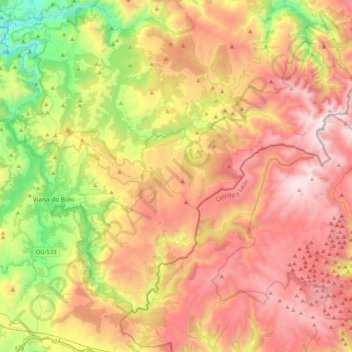
Name: ZEC Pena Trevinca topographic map, elevation, terrain.
Average elevation: 1,223 m
Minimum elevation: 347 m
Maximum elevation: 2,113 m
Make a donation
Gear up for your next adventure:
As an Amazon Associate, this site earns from qualifying purchases at no extra cost to you.