Geolocate

Ahuano topographic map

Click on the map to display elevation.

About this map

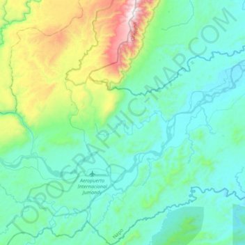
Name: Ahuano topographic map, elevation, terrain.

Location: Ahuano, Tena, Napo, Ecuador (-1.15760 -77.63219 -0.81861 -77.43330)

Average elevation: 560 m

Minimum elevation: 301 m

Maximum elevation: 1,694 m

Other topographic maps

Click on a map to view its topography, its elevation and its terrain.

Largato Cocha

Ecuador > Napo > Tena > Pano

Average elevation: 610 m

Gear up for your next adventure:

🧦Crew Hiking Socks - Comfortable socks for long-distance hikes
🧼Travel Hand Sanitizer - Keep hands clean when water is scarce
👖Convertible Hiking Pants - Zip-off legs to adapt to changing weather conditions
🦶Hiking Shoe Insoles - Added support for high arches and long days on feet
🧳Compression Sacks - Maximize space in your backpack by shrinking gear

As an Amazon Associate, this site earns from qualifying purchases at no extra cost to you.