Geolocate

Umeå topographic map

Click on the map to display elevation.

About this map

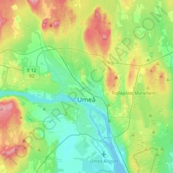
Name: Umeå topographic map, elevation, terrain.

Location: Umeå, Umeå kommun, Västerbotten County, Sweden (63.78556 20.13384 63.88203 20.38535)

Average elevation: 33 m

Minimum elevation: -5 m

Maximum elevation: 98 m

Other topographic maps

Click on a map to view its topography, its elevation and its terrain.

Ramsan

Sweden > Västerbotten County > Ramsele

Average elevation: 220 m

Lycksele

Sweden > Västerbotten County

Average elevation: 251 m

Gear up for your next adventure:

🔦LED Headlamp - Hands-free lighting for early morning starts or late finishes
💧Hydration Pack - Hands-free hydration system for long hikes
Bushcraft Tarp - Versatile emergency shelter or gear protection
🥽Outdoor Goggles - Protective eyewear for outdoor activities
Camping Coffee Maker - Brew fresh coffee anywhere on the topographic map

As an Amazon Associate, this site earns from qualifying purchases at no extra cost to you.