Geolocate

Chupallar Alto topographic map

Click on the map to display elevation.

About this map

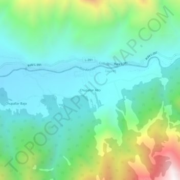
Name: Chupallar Alto topographic map, elevation, terrain.

Location: Chupallar Alto, Linares, Provincia de Linares, Región del Maule, Chile (-35.88408 -71.24296 -35.84408 -71.20296)

Average elevation: 830 m

Minimum elevation: 498 m

Maximum elevation: 1,783 m

Other topographic maps

Click on a map to view its topography, its elevation and its terrain.

Batuco

Chile > Región del Maule > Provincia de Linares > Linares

Average elevation: 159 m

Gear up for your next adventure:

🏕️Camping Hammock - Integrated protection for sleeping between trees
🛏️Camping Sleeping Mat - Comfortable mats for sleeping outdoors
🎒Hiking Backpack - Lightweight and ergonomic backpacks for day hikes or multi-day treks
🧭GPS Tracker - Track your location in remote areas safely
🥾Lightweight Hiking Shoes - Comfortable shoes for day hikes

As an Amazon Associate, this site earns from qualifying purchases at no extra cost to you.