Geolocate

San Gil topographic map

Click on the map to display elevation.

About this map

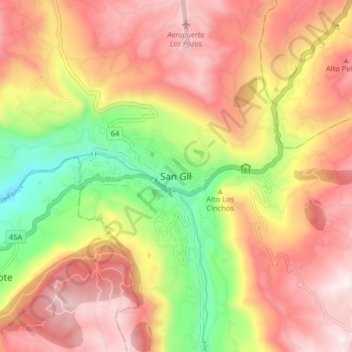
Name: San Gil topographic map, elevation, terrain.

Location: San Gil, Guanentá, Santander, 684031, Colombia (6.51529 -73.17124 6.59529 -73.09124)

Average elevation: 1,415 m

Minimum elevation: 973 m

Maximum elevation: 1,761 m

Gear up for your next adventure:

🐕Hiking Dog Pack - Let your canine companion carry their own water and food
🧴Waterproofing Spray - Restore the DWR coating on jackets and tents
🔭Compact Binoculars - Lightweight optics for scouting trails and wildlife
🎒Backpack Rain Cover - External shield to keep your entire pack dry
🕯️Camping Lantern - Illuminates your entire campsite with high-efficiency LEDs

As an Amazon Associate, this site earns from qualifying purchases at no extra cost to you.