
Make a donation
Gear up for your next adventure:
As an Amazon Associate, this site earns from qualifying purchases at no extra cost to you.
Col d'Ilhéou topographic map
Click on the map to display elevation.
Make a donation
Gear up for your next adventure:
As an Amazon Associate, this site earns from qualifying purchases at no extra cost to you.
Col d'Ilhéou
Le col d'Ilhéou est un col de montagne pédestre des Pyrénées françaises à 2 256 mètres d'altitude, dans le Lavedan, dans le département des Hautes-Pyrénées en Occitanie.
Make a donation
Gear up for your next adventure:
As an Amazon Associate, this site earns from qualifying purchases at no extra cost to you.
About this map
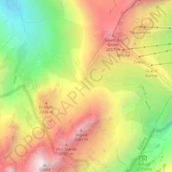
Name: Col d'Ilhéou topographic map, elevation, terrain.
Average elevation: 2,203 m
Minimum elevation: 1,569 m
Maximum elevation: 2,794 m
Make a donation
Gear up for your next adventure:
As an Amazon Associate, this site earns from qualifying purchases at no extra cost to you.
Other topographic maps
Click on a map to view its topography, its elevation and its terrain.