Geolocate

Kopparberg topographic map

Click on the map to display elevation.

👉 Easily get elevation data in JSON, GeoTIFF and KML formats using Elevation API
Thank you for supporting this site ❤️
Make a donation

Kopparberg

Although Kopparberg is slightly further south, it is located at a slightly higher elevation 6 kilometres (3.7 mi) south-east, rendering likely values very similar. Winter highs usually average just below freezing, and frosts are frequent from October through April. Summers are very tempered, compared to both the Mälar Valley to the south and east and central Dalarna to the north. The warmest recorded temperature of 34.2 °C (93.6 °F) is still high by Swedish standards, courtesy of the unpredictability of its far inland position.

Wikipedia (CC-BY-SA 3.0)

About this map

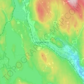
Name: Kopparberg topographic map, elevation, terrain.

Location: Kopparberg, Ljusnarsbergs kommun, Örebro County, 714 31, Sweden (59.83451 14.95038 59.91451 15.03038)

Average elevation: 196 m

Minimum elevation: 106 m

Maximum elevation: 380 m

Other topographic maps

Click on a map to view its topography, its elevation and its terrain.

Hallsbergs kommun

Sweden > Örebro County

Average elevation: 92 m

Malingsbo-Kloten

Sweden > Örebro County

Average elevation: 274 m

Laxå kommun

Sweden > Örebro County

Average elevation: 116 m

Örebro kommun

Sweden > Örebro County

Average elevation: 64 m

Örebro kommun

Sweden > Örebro County

Average elevation: 64 m

Gear up for your next adventure:

🚑Survival Whistle - Signal for help across long distances in mountains
🏃Hydration Running Vest - Carry water and maps close to your body for speed
🥾Approach Boots - Comfortable boots for hiking and climbing approaches
🦟Insect Repellent - Keep mosquitoes and black flies away in wooded areas
🧴Sunscreen SPF - Broad-spectrum sunscreen for outdoor activities

As an Amazon Associate, this site earns from qualifying purchases at no extra cost to you.