
Thank you for supporting this site ❤️
Make a donation
Make a donation
Gear up for your next adventure:
As an Amazon Associate, this site earns from qualifying purchases at no extra cost to you.
Ledrosee topographic map
Click on the map to display elevation.
Thank you for supporting this site ❤️
Make a donation
Make a donation
Gear up for your next adventure:
As an Amazon Associate, this site earns from qualifying purchases at no extra cost to you.
Ledrosee
Der Lago di Ledro liegt auf 655 m s.l.m. Höhe zwischen dem Gardasee und dem Idrosee am Ostende des Valle di Ledro. Der See hat eine Fläche von 2,187 km². Die tiefste Stelle liegt 47 m unter der Wasseroberfläche.
Thank you for supporting this site ❤️
Make a donation
Make a donation
Gear up for your next adventure:
As an Amazon Associate, this site earns from qualifying purchases at no extra cost to you.
About this map
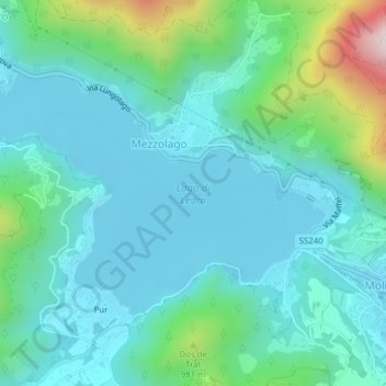
Name: Ledrosee topographic map, elevation, terrain.
Average elevation: 766 m
Minimum elevation: 643 m
Maximum elevation: 1,290 m
Thank you for supporting this site ❤️
Make a donation
Make a donation
Gear up for your next adventure:
As an Amazon Associate, this site earns from qualifying purchases at no extra cost to you.