Geolocate

Silun topographic map

Interactive map

Click on the map to display elevation.

About this map

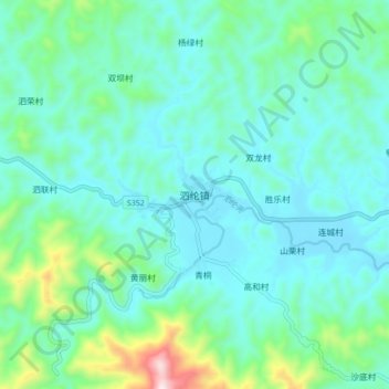
Name: Silun topographic map, elevation, terrain.

Location: Silun, Luoding, Yunfu City, Guangdong Province, China (22.67535 111.27757 22.75535 111.35757)

Average elevation: 191 m

Minimum elevation: 72 m

Maximum elevation: 721 m

Other topographic maps

Click on a map to view its topography, its elevation and its terrain.

Jinji

China > Guangdong Province > Luoding

Jinji, Luoding, Yunfu City, Guangdong Province, China

Average elevation: 185 m

Luoding

China > Guangdong Province > Luoding > Luocheng Subdistrict

Luoding, Luocheng Subdistrict, Luoding, Yunfu City, Guangdong Province, 527200, China

Average elevation: 122 m

Pingtang

China > Guangdong Province > Luoding

Pingtang, Luoding, Yunfu City, Guangdong Province, China

Average elevation: 131 m