
Thank you for supporting this site ❤️
Make a donation
Make a donation
Gear up for your next adventure:
As an Amazon Associate, this site earns from qualifying purchases at no extra cost to you.
Paucamarca topographic map
Click on the map to display elevation.
Thank you for supporting this site ❤️
Make a donation
Make a donation
Gear up for your next adventure:
As an Amazon Associate, this site earns from qualifying purchases at no extra cost to you.
About this map
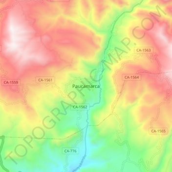
Name: Paucamarca topographic map, elevation, terrain.
Location: Paucamarca, Gregorio Pita, San Marcos, Cajamarca, Perú (-7.31366 -78.19984 -7.23366 -78.11984)
Average elevation: 2,914 m
Minimum elevation: 2,318 m
Maximum elevation: 3,492 m
Thank you for supporting this site ❤️
Make a donation
Make a donation
Gear up for your next adventure:
As an Amazon Associate, this site earns from qualifying purchases at no extra cost to you.