Geolocate

Ciemas topographic map

Click on the map to display elevation.

About this map

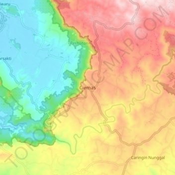
Name: Ciemas topographic map, elevation, terrain.

Location: Ciemas, Sukabumi, West Java, Java, Indonesia (-7.27290 106.47846 -7.19290 106.55846)

Average elevation: 225 m

Minimum elevation: 4 m

Maximum elevation: 477 m

Other topographic maps

Click on a map to view its topography, its elevation and its terrain.

Cibodas

Indonesia > West Java > Sukabumi > Cimenteng

Average elevation: 260 m

Cisolok

Indonesia > West Java > Sukabumi

Average elevation: 62 m

Cikahuripan

Indonesia > West Java > Sukabumi

Average elevation: 110 m

Gear up for your next adventure:

🔋Solar Power Bank - Keep your GPS and devices charged during long outdoor trips
🕶️Polarized Sunglasses - Protect your eyes with durable polarized lenses
🧼Biodegradable Camp Soap - Environmentally friendly cleaning for gear and body
🧰Survival Kit - Essential gear for emergencies in the wilderness
🕯️Camping Lantern - Illuminates your entire campsite with high-efficiency LEDs

As an Amazon Associate, this site earns from qualifying purchases at no extra cost to you.