Geolocate

Ciruas topographic map

Click on the map to display elevation.

About this map

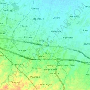
Name: Ciruas topographic map, elevation, terrain.

Location: Ciruas, Kab Serang, Banten, Java, 42116, Indonesia (-6.16549 106.19363 -6.08549 106.27363)

Average elevation: 17 m

Minimum elevation: 5 m

Maximum elevation: 45 m

Gear up for your next adventure:

💧Hydration Bladder - Hands-free hydration solution for long treks
🕶️Polarized Sunglasses - Protect your eyes with durable polarized lenses
🔦UV Flashlight - Detect minerals or specific insects in the dark
Tent Footprint - Protect tent floor and increase durability
🥫Freeze-Dried Meals - Lightweight, high-calorie nutrition for multi-day treks

As an Amazon Associate, this site earns from qualifying purchases at no extra cost to you.