
Make a donation
Gear up for your next adventure:
As an Amazon Associate, this site earns from qualifying purchases at no extra cost to you.
Gollmuthhausen topographic map
Click on the map to display elevation.
Make a donation
Gear up for your next adventure:
As an Amazon Associate, this site earns from qualifying purchases at no extra cost to you.
About this map
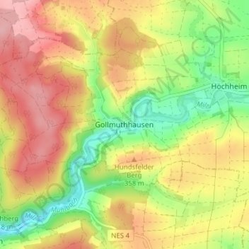
Name: Gollmuthhausen topographic map, elevation, terrain.
Average elevation: 334 m
Minimum elevation: 269 m
Maximum elevation: 392 m
Make a donation
Gear up for your next adventure:
As an Amazon Associate, this site earns from qualifying purchases at no extra cost to you.
Other topographic maps
Click on a map to view its topography, its elevation and its terrain.
Ostheim vor der Rhön
Deutschland > Bayern > Landkreis Rhön-Grabfeld
Um Ostheim vor der Rhön befinden sich Himmelsbeobachtungsplätze im Sternenpark Rhön, mit Aussichtspunkten nach oben mit Infotafeln und Hilfsmaterial. Um den 12. August, dem Höhepunkt des Perseidenstroms mit seinen Sternschnuppen, werden in dem Sternenpark auch Nachtveranstaltungen angeboten.
Average elevation: 369 m
Stockheim
Deutschland > Bayern > Landkreis Rhön-Grabfeld
Zum Dorf gehörten auch zwei Tore. Das Untere Tor stand nach der Brückengasse aus Richtung Mellrichstadt, das Obere Tor war auf Höhe der Gartenstraße, wenn das Dorf von Ostheim kommend auf der Hauptstraße erreicht wird. Über den Bau des Oberen Tores wurde am 30. April 1864 beraten, Brief und Siegel…
Average elevation: 363 m