
Make a donation
Gear up for your next adventure:
As an Amazon Associate, this site earns from qualifying purchases at no extra cost to you.
Vhembe District Municipality topographic map
Click on the map to display elevation.
Make a donation
Gear up for your next adventure:
As an Amazon Associate, this site earns from qualifying purchases at no extra cost to you.
About this map
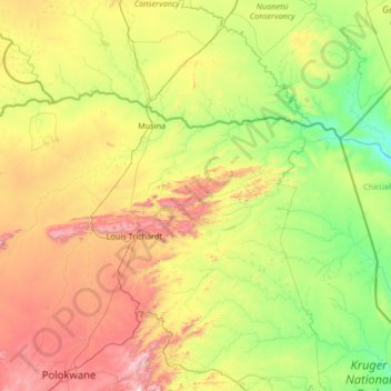
Name: Vhembe District Municipality topographic map, elevation, terrain.
Location: Vhembe District Municipality, Limpopo, South Africa (-23.43741 28.90197 -22.12503 31.56360)
Average elevation: 634 m
Minimum elevation: 168 m
Maximum elevation: 2,049 m
Make a donation
Gear up for your next adventure:
As an Amazon Associate, this site earns from qualifying purchases at no extra cost to you.
Other topographic maps
Click on a map to view its topography, its elevation and its terrain.
Thohoyandou
South Africa > Limpopo > Vhembe District Municipality > Thulamela Local Municipality
Average elevation: 632 m
Sekgakgapeng
South Africa > Limpopo > Waterberg District Municipality > Mogalakwena Local Municipality
Average elevation: 1,118 m
Burgersfort
South Africa > Limpopo > Sekhukhune District Municipality > Greater Tubatse Local Municipality
Average elevation: 810 m
Malamulele
South Africa > Limpopo > Vhembe District Municipality > Thulamela Local Municipality
Average elevation: 542 m
Make a donation
Gear up for your next adventure:
As an Amazon Associate, this site earns from qualifying purchases at no extra cost to you.
Tzaneen
South Africa > Limpopo > Mopani District Municipality > Greater Tzaneen Local Municipality
Average elevation: 737 m
Giyani
South Africa > Limpopo > Mopani District Municipality > Greater Giyani Local Municipality
Average elevation: 481 m
Mashamba
South Africa > Limpopo > Vhembe District Municipality > Makhado Local Municipality
Average elevation: 587 m
Make a donation
Gear up for your next adventure:
As an Amazon Associate, this site earns from qualifying purchases at no extra cost to you.
Groblersdal
South Africa > Limpopo > Sekhukhune District Municipality > Elias Motsoaledi Local Municipality
Average elevation: 939 m
Phiphidi Waterfall
South Africa > Limpopo > Vhembe District Municipality > Thulamela Local Municipality
Average elevation: 781 m
Modimolle
South Africa > Limpopo > Waterberg District Municipality > Modimolle Local Municipality
Average elevation: 1,192 m
Make a donation
Gear up for your next adventure:
As an Amazon Associate, this site earns from qualifying purchases at no extra cost to you.
Lebowakgomo
South Africa > Limpopo > Capricorn District Municipality > Lepelle-Nkumpi Local Municipality
Average elevation: 1,017 m
Mogalakwena
South Africa > Limpopo > Waterberg District Municipality > Mogalakwena Local Municipality
Average elevation: 855 m
Nkowankowa
South Africa > Limpopo > Mopani District Municipality > Greater Tzaneen Local Municipality
Average elevation: 544 m
Ga-Molepo
South Africa > Limpopo > Capricorn District Municipality > Polokwane Local Municipality
Average elevation: 1,291 m
Make a donation
Gear up for your next adventure:
As an Amazon Associate, this site earns from qualifying purchases at no extra cost to you.
Ga-Masemola
South Africa > Limpopo > Sekhukhune District Municipality > Makhuduthamaga Local Municipality
Average elevation: 911 m
Namakgale - B
South Africa > Limpopo > Mopani District Municipality > Ba-Phalaborwa Local Municipality
Average elevation: 410 m
De Hoop Dam
South Africa > Limpopo > Sekhukhune District Municipality > Elias Motsoaledi Local Municipality
Average elevation: 906 m
Phalaborwa
South Africa > Limpopo > Mopani District Municipality > Ba-Phalaborwa Local Municipality
Average elevation: 419 m
Make a donation
Gear up for your next adventure:
As an Amazon Associate, this site earns from qualifying purchases at no extra cost to you.
Bela-Bela
South Africa > Limpopo > Waterberg District Municipality > Bela Bela Local Municipality
Average elevation: 1,158 m
Thabazimbi
South Africa > Limpopo > Waterberg District Municipality > Thabazimbi Local Municipality
Average elevation: 1,077 m
Hoedspruit
South Africa > Limpopo > Mopani District Municipality > Maruleng Local Municipality
Average elevation: 524 m
Make a donation
Gear up for your next adventure:
As an Amazon Associate, this site earns from qualifying purchases at no extra cost to you.
Thononda
South Africa > Limpopo > Vhembe District Municipality > Mutale Local Municipality
Average elevation: 1,295 m
Mankweng
South Africa > Limpopo > Capricorn District Municipality > Polokwane Local Municipality
Average elevation: 1,300 m
Letsitele
South Africa > Limpopo > Mopani District Municipality > Greater Tzaneen Local Municipality
Average elevation: 562 m
Folovhodwe
South Africa > Limpopo > Vhembe District Municipality > Mutale Local Municipality
Average elevation: 523 m
Make a donation
Gear up for your next adventure:
As an Amazon Associate, this site earns from qualifying purchases at no extra cost to you.
Manyii
South Africa > Limpopo > Vhembe District Municipality > Makhado Local Municipality
Average elevation: 912 m
Lephalale
South Africa > Limpopo > Waterberg District Municipality > Lephalale Local Municipality
Average elevation: 831 m
Valdezia
South Africa > Limpopo > Vhembe District Municipality > Makhado Local Municipality
Average elevation: 737 m
Make a donation
Gear up for your next adventure:
As an Amazon Associate, this site earns from qualifying purchases at no extra cost to you.
Mogwadi
South Africa > Limpopo > Capricorn District Municipality > Molemole Local Municipality
Average elevation: 1,029 m
Vaalwater
South Africa > Limpopo > Waterberg District Municipality > Modimolle Local Municipality
Average elevation: 1,183 m
Haenertsburg
South Africa > Limpopo > Mopani District Municipality > Greater Tzaneen Local Municipality
Average elevation: 1,450 m
Lenyenye
South Africa > Limpopo > Mopani District Municipality > Ba-Phalaborwa Local Municipality
Average elevation: 449 m
Make a donation
Gear up for your next adventure:
As an Amazon Associate, this site earns from qualifying purchases at no extra cost to you.
Ga-Monene
South Africa > Limpopo > Waterberg District Municipality > Mogalakwena Local Municipality
Average elevation: 934 m
Leeupoort Vakansiedorp
South Africa > Limpopo > Waterberg District Municipality > Thabazimbi Local Municipality
Average elevation: 1,087 m
Molepo
South Africa > Limpopo > Sekhukhune District Municipality > Greater Tubatse Local Municipality
Average elevation: 872 m
Masodi
South Africa > Limpopo > Waterberg District Municipality > Mogalakwena Local Municipality
Average elevation: 1,072 m
Make a donation
Gear up for your next adventure:
As an Amazon Associate, this site earns from qualifying purchases at no extra cost to you.
Chillas
South Africa > Limpopo > Vhembe District Municipality > Thulamela Local Municipality
Average elevation: 445 m
Mbhokota Village
South Africa > Limpopo > Vhembe District Municipality > Makhado Local Municipality
Average elevation: 792 m
Jane Furse Memorial Lake
South Africa > Limpopo > Sekhukhune District Municipality > Makhuduthamaga Local Municipality > Mashadi
Average elevation: 1,393 m
Make a donation
Gear up for your next adventure:
As an Amazon Associate, this site earns from qualifying purchases at no extra cost to you.
Ga-Molepo
South Africa > Limpopo > Capricorn District Municipality > Polokwane Local Municipality
Average elevation: 1,291 m
Malavuwe
South Africa > Limpopo > Vhembe District Municipality > Thulamela Local Municipality
Average elevation: 522 m
Zandspruit
South Africa > Limpopo > Mopani District Municipality > Maruleng Local Municipality
Average elevation: 541 m
Northam
South Africa > Limpopo > Waterberg District Municipality > Thabazimbi Local Municipality
Average elevation: 1,013 m
Make a donation
Gear up for your next adventure:
As an Amazon Associate, this site earns from qualifying purchases at no extra cost to you.
Lapalala Wilderness Reserve
South Africa > Limpopo > Waterberg District Municipality
Average elevation: 1,136 m
Nkowankowa - C
South Africa > Limpopo > Mopani District Municipality > Greater Tzaneen Local Municipality
Average elevation: 532 m
Dzanani
South Africa > Limpopo > Vhembe District Municipality > Makhado Local Municipality
Average elevation: 833 m
Alverton
South Africa > Limpopo > Sekhukhune District Municipality > Greater Tubatse Local Municipality
Average elevation: 759 m
Make a donation
Gear up for your next adventure:
As an Amazon Associate, this site earns from qualifying purchases at no extra cost to you.
Nandoni Dam
South Africa > Limpopo > Vhembe District Municipality > Thulamela Local Municipality
Average elevation: 503 m
Mtititi
South Africa > Limpopo > Vhembe District Municipality > Thulamela Local Municipality
Average elevation: 475 m
Selati River
South Africa > Limpopo > Mopani District Municipality > Ba-Phalaborwa Local Municipality
Average elevation: 408 m
Tshipise
South Africa > Limpopo > Vhembe District Municipality > Mutale Local Municipality
Average elevation: 470 m
Make a donation
Gear up for your next adventure:
As an Amazon Associate, this site earns from qualifying purchases at no extra cost to you.
Steelpoort
South Africa > Limpopo > Sekhukhune District Municipality > Greater Tubatse Local Municipality
Average elevation: 854 m
Doorndraai Dam
South Africa > Limpopo > Waterberg District Municipality > Mookgopong Local Municipality
Average elevation: 1,258 m
Mahubahuba
South Africa > Limpopo > Sekhukhune District Municipality > Greater Tubatse Local Municipality
Average elevation: 752 m
Tzaneen Dam
South Africa > Limpopo > Mopani District Municipality > Greater Tzaneen Local Municipality
Average elevation: 721 m
Make a donation
Gear up for your next adventure:
As an Amazon Associate, this site earns from qualifying purchases at no extra cost to you.
Pienaarsrivier
South Africa > Limpopo > Waterberg District Municipality > Bela Bela Local Municipality
Average elevation: 1,042 m
The Oaks
South Africa > Limpopo > Mopani District Municipality > Maruleng Local Municipality
Average elevation: 483 m
Rapitsi
South Africa > Limpopo > Capricorn District Municipality > Aganang Local Municipality
Average elevation: 1,141 m
Make a donation
Gear up for your next adventure:
As an Amazon Associate, this site earns from qualifying purchases at no extra cost to you.
Zandspruit
South Africa > Limpopo > Mopani District Municipality > Maruleng Local Municipality > Hoedspruit
Average elevation: 511 m
Welgevonden Nature Reserve
South Africa > Limpopo > Waterberg District Municipality > Mokopane
Average elevation: 1,356 m
Mutale
South Africa > Limpopo > Vhembe District Municipality > Mutale Local Municipality
Average elevation: 755 m
Make a donation
Gear up for your next adventure:
As an Amazon Associate, this site earns from qualifying purchases at no extra cost to you.
Marble Hall
South Africa > Limpopo > Sekhukhune District Municipality > Ephraim Mogale Local Municipality
Average elevation: 892 m
Valdezia
South Africa > Limpopo > Vhembe District Municipality > Makhado Local Municipality
Average elevation: 737 m
Tzaneen
South Africa > Limpopo > Mopani District Municipality > Greater Tzaneen Local Municipality
Average elevation: 737 m
Make a donation
Gear up for your next adventure:
As an Amazon Associate, this site earns from qualifying purchases at no extra cost to you.
Mutale
South Africa > Limpopo > Vhembe District Municipality > Thulamela Local Municipality
Average elevation: 1,016 m
Mashadi
South Africa > Limpopo > Sekhukhune District Municipality > Makhuduthamaga Local Municipality
Average elevation: 1,358 m
Ga-Molepo
South Africa > Limpopo > Capricorn District Municipality > Polokwane Local Municipality
Average elevation: 1,291 m
Make a donation
Gear up for your next adventure:
As an Amazon Associate, this site earns from qualifying purchases at no extra cost to you.
Phiphidi Waterfall
South Africa > Limpopo > Vhembe District Municipality > Thulamela Local Municipality
Average elevation: 781 m
Soekmekaar (Morebeng)
South Africa > Limpopo > Capricorn District Municipality > Molemole Local Municipality
Average elevation: 1,158 m
Elim
South Africa > Limpopo > Vhembe District Municipality > Makhado Local Municipality
Average elevation: 869 m
Mogalakwena River
South Africa > Limpopo > Waterberg District Municipality > Mokopane
Average elevation: 1,078 m
Make a donation
Gear up for your next adventure:
As an Amazon Associate, this site earns from qualifying purchases at no extra cost to you.
Hoedspruit
South Africa > Limpopo > Mopani District Municipality > Maruleng Local Municipality
Average elevation: 524 m
Thohoyandou
South Africa > Limpopo > Vhembe District Municipality > Thulamela Local Municipality
Average elevation: 632 m
Tzaneen
South Africa > Limpopo > Mopani District Municipality > Greater Tzaneen Local Municipality
Average elevation: 737 m
Modimolle
South Africa > Limpopo > Waterberg District Municipality > Modimolle Local Municipality
Average elevation: 1,192 m
Make a donation
Gear up for your next adventure:
As an Amazon Associate, this site earns from qualifying purchases at no extra cost to you.
Lebowakgomo
South Africa > Limpopo > Capricorn District Municipality > Lepelle-Nkumpi Local Municipality
Average elevation: 1,017 m
Lenyenye
South Africa > Limpopo > Mopani District Municipality > Ba-Phalaborwa Local Municipality
Average elevation: 449 m
Lenyenye
South Africa > Limpopo > Mopani District Municipality > Ba-Phalaborwa Local Municipality
Average elevation: 448 m
Make a donation
Gear up for your next adventure:
As an Amazon Associate, this site earns from qualifying purchases at no extra cost to you.
Thohoyandou
South Africa > Limpopo > Vhembe District Municipality > Thulamela Local Municipality
Average elevation: 632 m
Moroke
South Africa > Limpopo > Sekhukhune District Municipality > Greater Tubatse Local Municipality
Average elevation: 815 m
Malamulele
South Africa > Limpopo > Vhembe District Municipality > Thulamela Local Municipality
Average elevation: 542 m
Modimolle
South Africa > Limpopo > Waterberg District Municipality > Modimolle Local Municipality
Average elevation: 1,192 m
Make a donation
Gear up for your next adventure:
As an Amazon Associate, this site earns from qualifying purchases at no extra cost to you.
Nkowankowa - A
South Africa > Limpopo > Mopani District Municipality > Greater Tzaneen Local Municipality
Average elevation: 557 m
Giyani
South Africa > Limpopo > Mopani District Municipality > Greater Giyani Local Municipality
Average elevation: 481 m
Make a donation
Gear up for your next adventure:
As an Amazon Associate, this site earns from qualifying purchases at no extra cost to you.
Groblersdal
South Africa > Limpopo > Sekhukhune District Municipality > Elias Motsoaledi Local Municipality
Average elevation: 939 m
Phiphidi Waterfall
South Africa > Limpopo > Vhembe District Municipality > Thulamela Local Municipality
Average elevation: 781 m
Hoedspruit
South Africa > Limpopo > Mopani District Municipality > Maruleng Local Municipality
Average elevation: 524 m
Selati River
South Africa > Limpopo > Mopani District Municipality > Ba-Phalaborwa Local Municipality
Average elevation: 408 m
Make a donation
Gear up for your next adventure:
As an Amazon Associate, this site earns from qualifying purchases at no extra cost to you.