Geolocate

Villers-sur-Mer topographic map

Click on the map to display elevation.

About this map
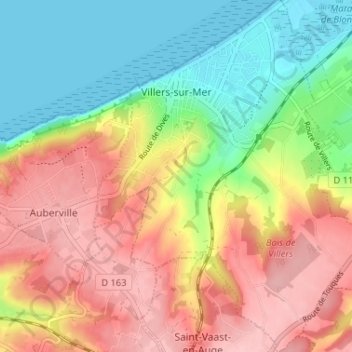
Name: Villers-sur-Mer topographic map, elevation, terrain.

Location: Villers-sur-Mer, Lisieux, Calvados, Normandy, Metropolitan France, 14640, France (49.29018 -0.02048 49.33272 0.03298)

Average elevation: 67 m

Minimum elevation: 0 m

Maximum elevation: 137 m

Other topographic maps

Click on a map to view its topography, its elevation and its terrain.
Omaha Beach

France > Normandy > Calvados > Vierville-sur-Mer

Average elevation: 21 m

Rauray

France > Normandy > Calvados > Tessel

Average elevation: 106 m

Gear up for your next adventure:

🧰Survival Kit - Essential gear for emergencies in the wilderness
💧Hydration Bladder - Hands-free hydration solution for long treks
🧣Merino Neck Gaiter - Protects against wind, sun, and cold at high altitudes
🐕Hiking Dog Pack - Let your canine companion carry their own water and food
🧤Rechargeable Heated Gloves - Extreme warmth for Canadian winter expeditions

As an Amazon Associate, this site earns from qualifying purchases at no extra cost to you.