Geolocate

Jebres topographic map

Click on the map to display elevation.

About this map

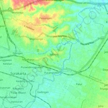
Name: Jebres topographic map, elevation, terrain.

Location: Jebres, Surakarta, Central Java, Java, 57126, Indonesia (-7.59495 110.81522 -7.51495 110.89522)

Average elevation: 101 m

Minimum elevation: 79 m

Maximum elevation: 154 m

Other topographic maps

Click on a map to view its topography, its elevation and its terrain.

Gear up for your next adventure:

🧦Hiking Liner Socks - Thin base layer to prevent friction and blisters
🔥Camping Stove - Portable stoves to cook outdoors with ease
🛌Insulated Sleeping Pad - Critical thermal barrier between you and the cold ground
🦶Hiking Shoe Insoles - Added support for high arches and long days on feet
🥾Trekking Boots - Durable boots for long-distance trekking

As an Amazon Associate, this site earns from qualifying purchases at no extra cost to you.