Geolocate

Sumowono topographic map

Click on the map to display elevation.

About this map

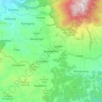
Name: Sumowono topographic map, elevation, terrain.

Location: Sumowono, Semarang, Central Java, Java, 50662, Indonesia (-7.26333 110.28133 -7.18333 110.36133)

Average elevation: 1,026 m

Minimum elevation: 575 m

Maximum elevation: 2,006 m

Other topographic maps

Click on a map to view its topography, its elevation and its terrain.

Rawa Pening

Indonesia > Central Java > Semarang > Rowoboni

Average elevation: 467 m

Gear up for your next adventure:

🧢Outdoor Visor - Breathable visor for sunny hikes
🧥Thermal Layer - Insulating layer for cold outdoor conditions
👟Trail Running Shoes - Agile footwear for fast-paced topographic exploration
🧶550 Survival Paracord - Versatile utility cord for emergency repairs and rigging
🔥Emergency Fire Starter - Reliable ignition source for all weather conditions

As an Amazon Associate, this site earns from qualifying purchases at no extra cost to you.